The phrase “Atmospheric River” is often erroneously used by the media attempting to link climate change and excessive rainfall events on the U.S. West Coast.
Atmospheric rivers are natural and normal parts of our global weather patterns, happening on the U.S. West coast on average every 1-3 years.
Geological Science has shown that extreme Atmospheric River events have occurred on the U.S. West Coast as far back as A.D. 212, occurring on average every 200 years.
Claims that climate change is making more severe Atmospheric Rivers are not supported by observational evidence, research on the phenomenon, or computer model projections.
Short Summary:
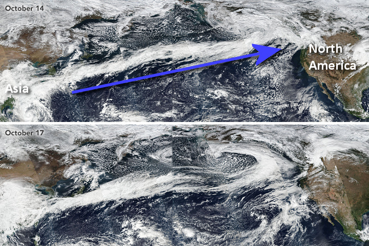
Atmospheric rivers are long, concentrated regions in the atmosphere that transport moist air from the tropics to higher latitudes. In Figure 1, satellite imagery from October 2017 illustrates how the long train of moisture, originating in Asia, makes its way across the Pacific Ocean to reach the U.S. West Coast.1
Figure 1. Composite satellite photos of an atmospheric river in the Pacific Ocean connecting Asia to North America in October 2017. The blue arrow shows the direction of travel. Original imagery from NASA Earth Observatory, annotation by Anthony Watts.
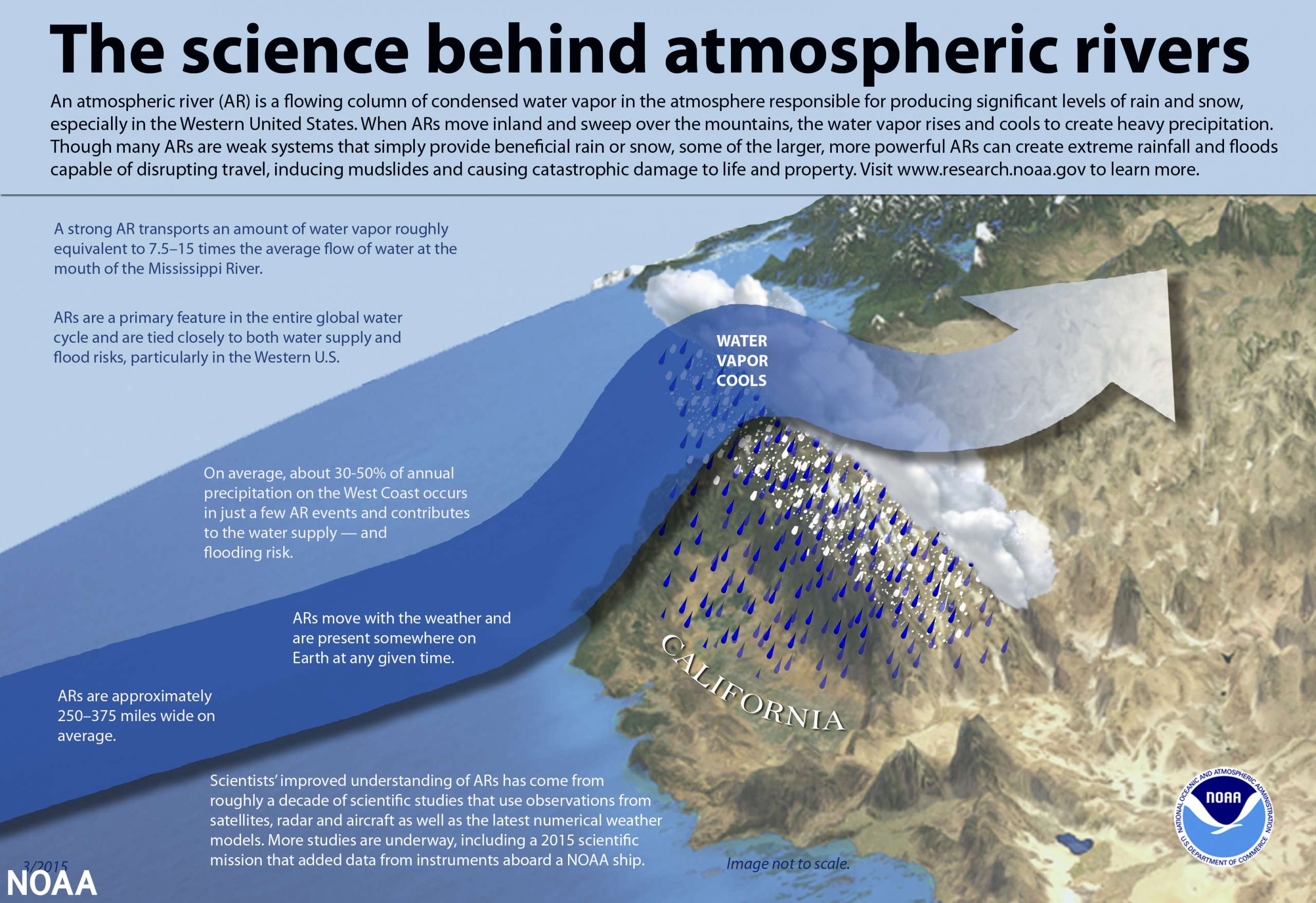
As shown in Figure 2 from the National Oceanic and Atmospheric Administration (NOAA), the moisture laden air, combined with high wind speeds, produce heavy rain and snow upon landfall, especially over mountainous terrain, such as in California, Oregon, and Washington.2
Figure 2. Infographic: The science behind atmospheric rivers. (Source: NOAA)
Extreme winter snowfall and rainfall events are not uncommon, and not every such event is the result of an Atmospheric River (AR) event. The west coast has always been prone to atmospheric river related severe weather events. From late 1861 into January 1862, the largest-ever atmospheric river event hit the west coast.
Known as the Great Flood of 1862, it was the largest in California’s recorded history. Weeks of continuous rains and snows in high elevations began November 1861 and continued into January 1862. This AR event dumped an equivalent of 10 feet of water on California, as rain and snow, over 43 days.3
The U.S. Geological Survey (USGS) investigated historical AR events by drilling core samples in San Francisco Bay and in lake and marsh sediments throughout California.5 The study positively identified the stream gravels deposited by the Great Flood of 1862. Core samples indicated that similar and even more devastating flooding occurred in AD 212, 440, 603, 1029, 1418, and 1605 — roughly every 200 years.
The USGS concluded that “[t]he geologic record shows 6 mega-storms more severe than 1861-1862 in California in the last 1800 years, and there is no reason to believe similar events won’t occur again.”6
Recent computer model simulations of the AR phenomena do not support claims that AR events are likely to become more severe or numerous in the future.7
The long-term observational and paleoclimatological records provide no support for claims that AR events have become more frequent or severe during the recent period of modest warming.
The phrase “Atmospheric River” is often erroneously used by the media attempting to link climate change and excessive rainfall events on the U.S. West Coast.
Atmospheric rivers are natural and normal parts of our global weather patterns, happening on the U.S. West coast on average every 1-3 years.
Geological Science has shown that extreme Atmospheric River events have occurred on the U.S. West Coast as far back as A.D. 212, occurring on average every 200 years.
Claims that climate change is making more severe Atmospheric Rivers are not supported by observational evidence, research on the phenomenon, or computer model projections.
Short Summary:
Atmospheric rivers are long, concentrated regions in the atmosphere that transport moist air from the tropics to higher latitudes. In Figure 1, satellite imagery from October 2017 illustrates how the long train of moisture, originating in Asia, makes its way across the Pacific Ocean to reach the U.S. West Coast.1
Figure 1. Composite satellite photos of an atmospheric river in the Pacific Ocean connecting Asia to North America in October 2017. The blue arrow shows the direction of travel. Original imagery from NASA Earth Observatory, annotation by Anthony Watts.
As shown in Figure 2 from the National Oceanic and Atmospheric Administration (NOAA), the moisture laden air, combined with high wind speeds, produce heavy rain and snow upon landfall, especially over mountainous terrain, such as in California, Oregon, and Washington.2
Figure 2. Infographic: The science behind atmospheric rivers. (Source: NOAA)
Extreme winter snowfall and rainfall events are not uncommon, and not every such event is the result of an Atmospheric River (AR) event. The west coast has always been prone to atmospheric river related severe weather events. From late 1861 into January 1862, the largest-ever atmospheric river event hit the west coast.
Known as the Great Flood of 1862, it was the largest in California’s recorded history. Weeks of continuous rains and snows in high elevations began November 1861 and continued into January 1862. This AR event dumped an equivalent of 10 feet of water on California, as rain and snow, over 43 days.3
The U.S. Geological Survey (USGS) investigated historical AR events by drilling core samples in San Francisco Bay and in lake and marsh sediments throughout California.5 The study positively identified the stream gravels deposited by the Great Flood of 1862. Core samples indicated that similar and even more devastating flooding occurred in AD 212, 440, 603, 1029, 1418, and 1605 — roughly every 200 years.
The USGS concluded that “[t]he geologic record shows 6 mega-storms more severe than 1861-1862 in California in the last 1800 years, and there is no reason to believe similar events won’t occur again.”6
Recent computer model simulations of the AR phenomena do not support claims that AR events are likely to become more severe or numerous in the future.7
The long-term observational and paleoclimatological records provide no support for claims that AR events have become more frequent or severe during the recent period of modest warming.
We use cookies to ensure that we give you the best experience on our website. If you continue to use this site we will assume that you are happy with it.Ok
